Bar nearby Bar Paradise
Coronavirus disease (COVID-19) Situation
confirmed cases
26723249
deaths
196487
Italy
Bar nearby Bar Paradise
Bar Paradise
Viale Gorizia, 37, Roma Italy
contacts phone
:
+39
Latitude:
41.9202304
, Longitude:
12.5105218
read more
nearest Bar
80 m
La Cannoleria Siciliana - Corso Trieste
Corso Trieste, 100, Roma
Bar
read more
150 m
Ceresa Immobiliare S.R.L.
Corso Trieste, 132, Roma
Bar
read more
154 m
Bar Gelateria
Corso Trieste, 72, Roma
Bar
read more
429 m
Umbertoel Sedawi Magdi Makhtar
Via Panaro, 22/24, Roma
Bar
read more
445 m
Bar Alex Srl
Via Chiana, 50/52, Roma
Bar
read more
449 m
Marino Alessandro
Via Spalato, 2, Roma
Bar
read more
526 m
D.f.e. srl
Via Tagliamento, 54, Roma
Bar
read more
694 m
Sere Bar
Via Novara, 45, Roma
Bar
read more
789 m
Bowling Roma
Viale Regina Margherita, 181, Roma
Bar
read more
798 m
Juice Bar
Largo XXI Aprile, 7, Roma
Bar
read more
802 m
Amodio Annunziato
Viale Regina Margherita, 146, Roma
Bar
read more
806 m
Caffè Chamonix
Viale Regina Margherita, 109, Roma
Bar
read more
846 m
Coffee Hour
Via Massaciuccoli, 67, Roma
Bar
read more
893 m
La Casa del Cremolato
Via di Priscilla, 18, Roma
Bar
read more
934 m
Mio Bar
Viale Regina Margherita, 39, Roma
Bar
read more
943 m
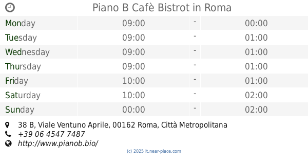
Piano B Cafè Bistrot
Viale Ventuno Aprile, 38 B, Roma
Bar
read more
961 m
La Petrilleria
Via Metauro, 55, Roma
Bar
read more
1.004 km
Suan Bar
Piazza Armellini Mariano, 9, Roma
Bar
read more
1.053 km
Mini Bar
Via Nomentana, 28, Roma
Bar
read more
1.062 km
Cafe' Art.
Via Catanzaro, 40-42, Roma
Bar
read more
1.123 km
enoteca boni e non solo di giulia pierozzi
Via Giacomo Boni, 32, Roma
Bar
read more
1.147 km
Bar Garden Di Terra Annamaria
Via Livorno, 13, Roma
Bar
read more
1.185 km
The Cathedral
Via Alessandria, 74, Roma
Bar
read more
1.246 km
Molinari Antonio
Via Brescia, 36, Roma
Bar
read more
1.305 km
Caffè dell'osteria
Via Nizza, Roma
Bar
read more
📑
all categories
Accounting
Administrative area level 1
Administrative area level 2
Airport
Amusement park
Aquarium
Art gallery
Atm
Bakery
Bank
Bar
Beauty salon
Bicycle store
Book store
Bowling alley
Bus station
Cafe
Campground
Car dealer
Car rental
Car repair
Car wash
Casino
Cemetery
Church
City hall
Clothing store
Colloquial area
Convenience store
Country
Courthouse
Dentist
Department store
Doctor
Electrician
Electronics store
Embassy
Finance
Fire station
Florist
Food
Funeral home
Furniture store
Gas station
General contractor
Grocery or supermarket
Gym
Hair care
Hardware store
Health
Hindu Temple
Home goods store
Hospital
Insurance agency
Jewelry store
Laundry
Lawyer
Library
Light rail station
Liquor store
Local government office
Locality
Locksmith
Lodging
Meal delivery
Meal takeaway
Mosque
Movie rental
Movie theater
Moving company
Museum
Natural feature
Neighborhood
Night club
Painter
Park
Parking
Pet store
Pharmacy
Physiotherapist
Place of worship
Plumber
Point of interest
Police
Political
Post office
Premise
Real estate agency
Restaurant
Roofing contractor
Route
Rv park, camping
School
Shoe store
Shopping mall
Spa
Stadium
Storage
Store
Subpremise
Subway station
Supermarket
Synagogue
Taxi stand
Train station
Transit station
Travel agency
University
Veterinary care
Zoo
administrative area level 3
sublocality level 1
↑