Cafe nearby L'Angolo Café
Italy
Cafe nearby L'Angolo Café
L'Angolo Café
Via Saldini, 4, Milano Italy
contacts phone
:
+39
Latitude:
45.4707627
, Longitude:
9.2276225
read more
nearest Cafe
268 m
Caffe' Moka Efti
Via Moretto da Brescia, Milano
Cafe
read more
420 m
Curry Bowl
Via Illirico, 6, Milano
Cafe
read more
461 m
Bar Pasticceria Vecchia Milano
Via Francesco Reina, 14, Milano
Cafe
read more
556 m
Bar Tabacchi Oasi
Via Filippo Juvara, 7, Milano
Cafe
read more
628 m
Caffetteria Pinocchio
Piazza Ermete Novelli, Milano
Cafe
read more
662 m
MisterTea
Via Giovanni Pascoli, 60, Milano
Cafe
read more
673 m
Bar Andrea 2
Via Giancarlo Sismondi, 53, Milano
Cafe
read more
698 m
Gelateria pasticceria Pinocchio
Via Gaio, 19, Milano
Cafe
read more
707 m
New Brand Cafe
Via Giovanni Pascoli, 55, Milano
Cafe
read more
733 m
Caffè Plinio 63 Milano srls
Via Plinio, 63, Milano
Cafe
read more
733 m
Caffè Plinio 63
Via Plinio, 63, Milano
Cafe
read more
813 m
Bar Sallas
Via Pinturicchio, 11, Milano
Cafe
read more
852 m
Bakery cafè
Città Studi, Milan
Cafe
read more
917 m
Cristal Cafè
Via Battistotti Sassi, 2, Milano
Cafe
read more
949 m
Nastia Caffè
Via Giuseppe Piolti de' Bianchi, 15, Milano
Cafe
read more
979 m
BAR TABACCHI MILLENIUM
Viale Corsica, 16, Milano
Cafe
read more
990 m
Caffe Bello
Corso Ventidue Marzo, 63, Milano
Cafe
read more
999 m
Buongiorno Milano
Corso Ventidue Marzo, 61, Milano
Cafe
read more
1.001 km
ASINO E BACCO
Piazza Giuseppe Grandi, 11, Milano
Cafe
read more
1.124 km
Happy Coffee
Corso Ventidue Marzo, 49, Milano
Cafe
read more
1.181 km
Fiordilatte Gelaterie
Via Plinio, 33, Milano
Cafe
read more
1.187 km
UMAMI MILANO
Piazza Emilia, 4, Milano
Cafe
read more
1.21 km
H&D Caffé Srl
Piazza Emilia, 9, Milano
Cafe
read more
1.271 km
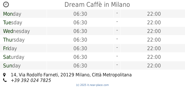
Dream Caffè
Via Rodolfo Farneti, 14, Milano
Cafe
read more
1.35 km
Steel Cafè
Via Fratelli Bronzetti, 37, Milano
Cafe
read more
📑
all categories
Accounting
Administrative area level 1
Administrative area level 2
Airport
Amusement park
Aquarium
Art gallery
Atm
Bakery
Bank
Bar
Beauty salon
Bicycle store
Book store
Bowling alley
Bus station
Cafe
Campground
Car dealer
Car rental
Car repair
Car wash
Casino
Cemetery
Church
City hall
Clothing store
Colloquial area
Convenience store
Country
Courthouse
Dentist
Department store
Doctor
Electrician
Electronics store
Embassy
Finance
Fire station
Florist
Food
Funeral home
Furniture store
Gas station
General contractor
Grocery or supermarket
Gym
Hair care
Hardware store
Health
Hindu Temple
Home goods store
Hospital
Insurance agency
Jewelry store
Laundry
Lawyer
Library
Light rail station
Liquor store
Local government office
Locality
Locksmith
Lodging
Meal delivery
Meal takeaway
Mosque
Movie rental
Movie theater
Moving company
Museum
Natural feature
Neighborhood
Night club
Painter
Park
Parking
Pet store
Pharmacy
Physiotherapist
Place of worship
Plumber
Point of interest
Police
Political
Post office
Premise
Real estate agency
Restaurant
Roofing contractor
Route
Rv park, camping
School
Shoe store
Shopping mall
Spa
Stadium
Storage
Store
Subpremise
Subway station
Supermarket
Synagogue
Taxi stand
Train station
Transit station
Travel agency
University
Veterinary care
Zoo
administrative area level 3
sublocality level 1
↑