Gas station nearby TotalErg
Coronavirus disease (COVID-19) Situation
confirmed cases
26723249
deaths
196487
Italy
Gas station nearby TotalErg
TotalErg
Tangenziale, SS16, Bari Italy
contacts phone
:
+39
Latitude:
41.141743
, Longitude:
16.8019177
read more
nearest Gas station
639 m
Q8
Lungomare IX Maggio, Bari
Gas station
read more
642 m
Indipendente Bari
Lungomare IX Maggio, Bari
Gas station
read more
2.029 km
ENI
Via Gabriele D'Annunzio, Bari
Gas station
read more
2.066 km
Q8Easy - Servizi & Gestioni Italia S.R.L.
Via Napoli, Bari
Gas station
read more
2.072 km
Blubell Srl (Q8)
Viale Europa, 1, Bari
Gas station
read more
2.099 km
Schima Michele
Viale delle Regioni, 20, Bari
Gas station
read more
2.104 km
Q8
Via Napoli, Bari
Gas station
read more
2.164 km
Stazione Di Servizio (Q8)
Via Napoli, 364, Bari
Gas station
read more
2.199 km
Antogi Distribuzione Snc
Viale Europa, 30, Bari
Gas station
read more
2.203 km
Tot
Viale Europa, Bari
Gas station
read more
2.209 km
Total Erg
Viale Europa, Bari
Gas station
read more
2.209 km
TotalErg
Viale Europa, Bari
Gas station
read more
2.675 km
Stazione Di Servizio Di De Lucia Domenico (Api)
Viale Saverio Mercadante, Bari
Gas station
read more
2.679 km
Ip
Viale Saverio Mercadante, Bari
Gas station
read more
2.757 km
Franco Vittorio E Francesco Snc
Via Napoli, 338, Bari
Gas station
read more
2.773 km
Eni
Via Napoli 338, Bari
Gas station
read more
2.904 km
IP
Via Napoli, 357, Bari
Gas station
read more
2.935 km
Iannola Giuseppe P.U. Api Ip
Via Pordenone,, Modugno
Gas station
read more
2.935 km
IP
Via Sicilia, Modugno
Gas station
read more
3.012 km
Stazione Metano
Viale Europa, 18, Bari
Gas station
read more
3.013 km
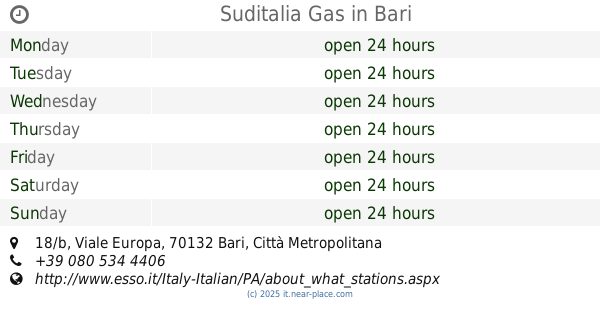
Esso SuditaliaGas srl
Italy
Gas station
read more
3.021 km
Suditalia Gas
Viale Europa, 18/b, Bari
Gas station
read more
3.079 km
Tamoil
Via Napoli, Bari
Gas station
read more
3.333 km
Q8
Viale Europa, Bari
Gas station
read more
3.336 km
Esso
Viale Europa, 18/B, Bari
Gas station
read more
📑
all categories
Accounting
Administrative area level 1
Administrative area level 2
Airport
Amusement park
Aquarium
Art gallery
Atm
Bakery
Bank
Bar
Beauty salon
Bicycle store
Book store
Bowling alley
Bus station
Cafe
Campground
Car dealer
Car rental
Car repair
Car wash
Casino
Cemetery
Church
City hall
Clothing store
Colloquial area
Convenience store
Country
Courthouse
Dentist
Department store
Doctor
Electrician
Electronics store
Embassy
Finance
Fire station
Florist
Food
Funeral home
Furniture store
Gas station
General contractor
Grocery or supermarket
Gym
Hair care
Hardware store
Health
Hindu Temple
Home goods store
Hospital
Insurance agency
Jewelry store
Laundry
Lawyer
Library
Light rail station
Liquor store
Local government office
Locality
Locksmith
Lodging
Meal delivery
Meal takeaway
Mosque
Movie rental
Movie theater
Moving company
Museum
Natural feature
Neighborhood
Night club
Painter
Park
Parking
Pet store
Pharmacy
Physiotherapist
Place of worship
Plumber
Point of interest
Police
Political
Post office
Premise
Real estate agency
Restaurant
Roofing contractor
Route
Rv park, camping
School
Shoe store
Shopping mall
Spa
Stadium
Storage
Store
Subpremise
Subway station
Supermarket
Synagogue
Taxi stand
Train station
Transit station
Travel agency
University
Veterinary care
Zoo
administrative area level 3
sublocality level 1
↑