Museum nearby Via Margutta
Italy
Museum nearby Via Margutta
Via Margutta
Via Margutta, 53, Roma Italia
contacts phone
:
+39
Latitude:
41.908143
, Longitude:
12.4800835
read more
nearest Museum
89 m
Ristorarte 1818 S.R.L
Via del Babuino, 150, Roma
Museum
read more
253 m
Casa di Goethe
Via del Corso, 18, Roma
Museum
read more
361 m
Anni Di Piombo
Piazza del Popolo, 18, Roma
Museum
read more
375 m
Fountain of Moses
Rione IV Campo Marzio, Roma
Museum
read more
404 m
Piazza Mignanelli
Piazza Mignanelli, Roma
Museum
read more
459 m
레오나르도 박물관
Piazza del Popolo, 12, Roma
Museum
read more
472 m
Galleria Giustini/Stagetti
38, Via della Fontanella di Borghese, Roma
Museum
read more
639 m
Museo Carlo Bilotti
Viale Fiorello la Guardia, 6, Roma
Museum
read more
673 m
Modern Art Gallery
Via Francesco Crispi, 24, Roma
Museum
read more
787 m
National Academy of San Luca
Piazza Accademia di San Luca, 77, Roma
Museum
read more
807 m
Fondazione Sorgente Group
Via del Tritone, 132, Roma
Museum
read more
886 m
Museo Egizio
Via Omero, 4, Roma
Museum
read more
922 m
Vicus Caprarius-the Water City
Vicolo del Puttarello, 25, Roma
Museum
read more
922 m
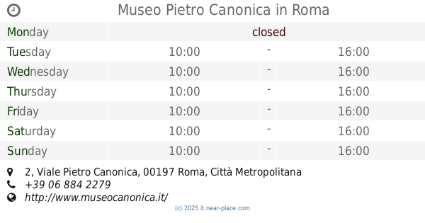
Museo Pietro Canonica
Viale Pietro Canonica, 2, Roma
Museum
read more
942 m
Steen Roeland
Vicolo della Spada d'Orlando, 73, Roma
Museum
read more
949 m
Scalinata Via della Panetteria
Roma
Museum
read more
980 m
Säulen
Vicolo Sciarra, 51, Roma
Museum
read more
1.105 km
Quirinal Palace
Piazza del Quirinale, Roma
Museum
read more
1.105 km
Quirinalpaladset
Piazza del Quirinale, Roma
Museum
read more
1.152 km
Arco della Pace - Turner
Arco della Pace, Roma
Museum
read more
1.188 km
Palazzo Del Drago
Via dei Coronari, 44, Roma
Museum
read more
1.201 km
Gebart S.r.l.
Via delle Quattro Fontane, 18, Roma
Museum
read more
1.204 km
Galeria Borghese
Piazzale Scipione Borghese, 5, Roma
Museum
read more
1.205 km
Centro Studi dell’Opera di Umberto Mastroianni
Piazza di San Salvatore in Lauro, 15, Roma
Museum
read more
1.275 km
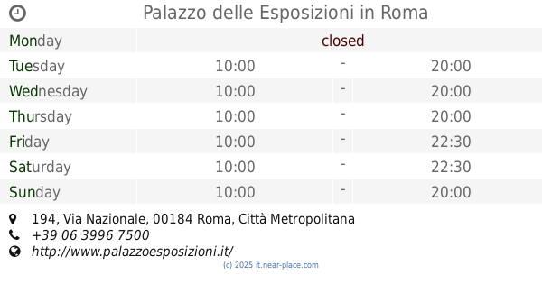
Palazzo delle Esposizioni
Via Nazionale, 194, Roma
Museum
read more
📑
all categories
Accounting
Administrative area level 1
Administrative area level 2
Airport
Amusement park
Aquarium
Art gallery
Atm
Bakery
Bank
Bar
Beauty salon
Bicycle store
Book store
Bowling alley
Bus station
Cafe
Campground
Car dealer
Car rental
Car repair
Car wash
Casino
Cemetery
Church
City hall
Clothing store
Colloquial area
Convenience store
Country
Courthouse
Dentist
Department store
Doctor
Electrician
Electronics store
Embassy
Finance
Fire station
Florist
Food
Funeral home
Furniture store
Gas station
General contractor
Grocery or supermarket
Gym
Hair care
Hardware store
Health
Hindu Temple
Home goods store
Hospital
Insurance agency
Jewelry store
Laundry
Lawyer
Library
Light rail station
Liquor store
Local government office
Locality
Locksmith
Lodging
Meal delivery
Meal takeaway
Mosque
Movie rental
Movie theater
Moving company
Museum
Natural feature
Neighborhood
Night club
Painter
Park
Parking
Pet store
Pharmacy
Physiotherapist
Place of worship
Plumber
Point of interest
Police
Political
Post office
Premise
Real estate agency
Restaurant
Roofing contractor
Route
Rv park, camping
School
Shoe store
Shopping mall
Spa
Stadium
Storage
Store
Subpremise
Subway station
Supermarket
Synagogue
Taxi stand
Train station
Transit station
Travel agency
University
Veterinary care
Zoo
administrative area level 3
sublocality level 1
↑