Night club nearby Saràvino
Coronavirus disease (COVID-19) Situation
confirmed cases
26723249
deaths
196487
Italy
Night club nearby Saràvino
Saràvino
Via Belvedere, 11, Bologna Italien
contacts phone
:
+39
Latitude:
44.4964441
, Longitude:
11.3384197
read more
nearest Night club
189 m
STUDIO 54
b,, Via San Felice, 6, Bologna
Night club
read more
194 m
Falentex House
Via delle Lame, 31, Bologna
Night club
read more
229 m
Valeria Lalli
Via San Lorenzo, 4, Bologna
Night club
read more
281 m
Millenium
Via Riva di Reno, Bologna
Night club
read more
504 m
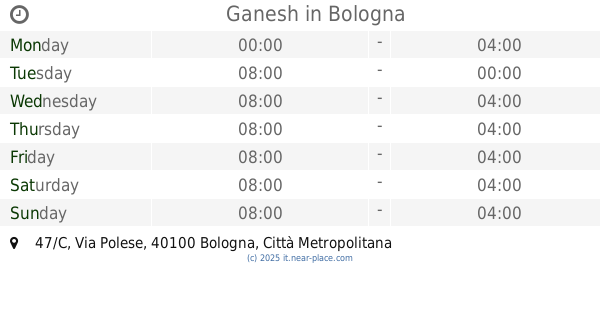
Ganesh
Via Polese, 47/C, Bologna
Night club
read more
568 m
Piedra del Sol
Via Goito, 20, Bologna
Night club
read more
605 m
Casa Vaira
16, Via Marsala, Bologna
Night club
read more
629 m
LOFT Kinodromo
Via San Rocco, 16, Bologna
Night club
read more
661 m
Bil
Via San Valentino, 2, Bologna
Night club
read more
717 m
Kinki Club
Via Zamboni, 1, Bologna
Night club
read more
740 m
Parcheggio
Via Fratelli Rosselli, 8, Bologna
Night club
read more
760 m
Cassero LGBT center
Via Don Giovanni Minzoni, 18, Bologna
Night club
read more
765 m
Qubò
Via Sampieri, 3, Bologna
Night club
read more
773 m
Nosferatu
Via Zamboni, 16, Bologna
Night club
read more
802 m
Soda Pops
Via Castel Tialto, 6, Bologna
Night club
read more
827 m
Kalypso discobar
Via del Borgo di San Pietro, 9, Bologna
Night club
read more
832 m
Pullman Bologna
Viale Antonio Silvani, 2-4, Bologna
Night club
read more
857 m
N2 srl
Via Mascarella, 2, Bologna
Night club
read more
870 m
Cantina Bentivoglio
Via Mascarella, 4/b, Bologna
Night club
read more
884 m
Hotel Touring Bologna
Via dè Mattuiani, 1, Bologna
Night club
read more
885 m
Art Rock Cafe
Vicolo Broglio, 2, Bologna
Night club
read more
896 m
K-Factory
Corte Isolani, 3a/b/c, Bologna
Night club
read more
933 m
PlayBoy
Via Lodovico Berti, 7, Bologna
Night club
read more
1.071 km
Piazzetta FM 07 11
Via San Domenico, 11, Bologna
Night club
read more
1.254 km
Excelsi Neptuni Balla
Via Santo Stefano, 47, Bologna
Night club
read more
📑
all categories
Accounting
Administrative area level 1
Administrative area level 2
Airport
Amusement park
Aquarium
Art gallery
Atm
Bakery
Bank
Bar
Beauty salon
Bicycle store
Book store
Bowling alley
Bus station
Cafe
Campground
Car dealer
Car rental
Car repair
Car wash
Casino
Cemetery
Church
City hall
Clothing store
Colloquial area
Convenience store
Country
Courthouse
Dentist
Department store
Doctor
Electrician
Electronics store
Embassy
Finance
Fire station
Florist
Food
Funeral home
Furniture store
Gas station
General contractor
Grocery or supermarket
Gym
Hair care
Hardware store
Health
Hindu Temple
Home goods store
Hospital
Insurance agency
Jewelry store
Laundry
Lawyer
Library
Light rail station
Liquor store
Local government office
Locality
Locksmith
Lodging
Meal delivery
Meal takeaway
Mosque
Movie rental
Movie theater
Moving company
Museum
Natural feature
Neighborhood
Night club
Painter
Park
Parking
Pet store
Pharmacy
Physiotherapist
Place of worship
Plumber
Point of interest
Police
Political
Post office
Premise
Real estate agency
Restaurant
Roofing contractor
Route
Rv park, camping
School
Shoe store
Shopping mall
Spa
Stadium
Storage
Store
Subpremise
Subway station
Supermarket
Synagogue
Taxi stand
Train station
Transit station
Travel agency
University
Veterinary care
Zoo
administrative area level 3
sublocality level 1
↑