Park nearby Fontana di S. Maria Maggiore
Coronavirus disease (COVID-19) Situation
confirmed cases
26723249
deaths
196487
Italy
Park nearby Fontana di S. Maria Maggiore
Fontana di S. Maria Maggiore
Piazza di San Maria Maggiore, Roma Italia
contacts phone
:
+39
Latitude:
41.8970584
, Longitude:
12.4993233
read more
nearest Park
15 m
Piazza di Santa María Maggiore
Roma
Park
read more
135 m
Fontana Paolina
Via Paolina, Roma
Park
read more
243 m
Fontana dei Monti
Via di San Vito, Roma
Park
read more
401 m
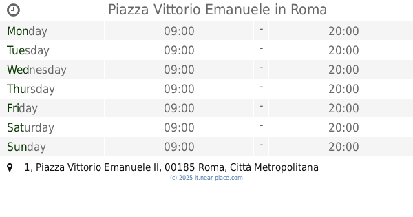
Piazza Vittorio Emanuele
Piazza Vittorio Emanuele II, 1, Roma
Park
read more
430 m
Parco per cani
Rione XV Esquilino, Roma
Park
read more
503 m
Giardini Nicola Calipari
Piazza Vittorio Emanuele II, 107-112, Roma
Park
read more
515 m
Giardini Nicola Calipari
Rom
Park
read more
515 m
Giardini Nicola Calipari
Rome
Park
read more
542 m
Children's play park
Rione I Monti, Roma
Park
read more
553 m
Giardino Confucio
Rione XV Esquilino, Roma
Park
read more
602 m
Il Giardino di Renato
Rione I Monti, Roma
Park
read more
655 m
Piazza Martin Lutero
Viale Fortunato Mizzi, Roma
Park
read more
664 m
Federparchi
Via Nazionale, 230, Roma
Park
read more
743 m
Fountain of the catechumens
Piazza della Madonna dei Monti, Roma
Park
read more
828 m
Giardinetto Del Monte Oppio
Via del Monte Oppio, Roma
Park
read more
869 m
Garden of Sant'Andrea al Quirinale
Via del Quirinale, 28, Roma
Park
read more
889 m
Le Quattro Fontane (L'Arno)
Via delle Quattro Fontane, Roma
Park
read more
912 m
Fontana del Colosseo
Piazza del Colosseo, Roma
Park
read more
913 m
Fontana del Mosè
Piazza di San Bernardo, Roma
Park
read more
947 m
Villa Carlo Alberto at the Quirinale
Via Piacenza, 4, Roma
Park
read more
1.046 km
Jardines del Quirinal
Traforo Umberto I, Roma
Park
read more
1.046 km
Giardini del Quirinale
Traforo Umberto I, Roma
Park
read more
1.096 km
Parco del Celio
Rome
Park
read more
1.175 km
Mia Land
Via Emanuele Filiberto, 138, Roma
Park
read more
1.279 km
Villa Wolkonsky
Via Ludovico di Savoia, 11, Roma
Park
read more
📑
all categories
Accounting
Administrative area level 1
Administrative area level 2
Airport
Amusement park
Aquarium
Art gallery
Atm
Bakery
Bank
Bar
Beauty salon
Bicycle store
Book store
Bowling alley
Bus station
Cafe
Campground
Car dealer
Car rental
Car repair
Car wash
Casino
Cemetery
Church
City hall
Clothing store
Colloquial area
Convenience store
Country
Courthouse
Dentist
Department store
Doctor
Electrician
Electronics store
Embassy
Finance
Fire station
Florist
Food
Funeral home
Furniture store
Gas station
General contractor
Grocery or supermarket
Gym
Hair care
Hardware store
Health
Hindu Temple
Home goods store
Hospital
Insurance agency
Jewelry store
Laundry
Lawyer
Library
Light rail station
Liquor store
Local government office
Locality
Locksmith
Lodging
Meal delivery
Meal takeaway
Mosque
Movie rental
Movie theater
Moving company
Museum
Natural feature
Neighborhood
Night club
Painter
Park
Parking
Pet store
Pharmacy
Physiotherapist
Place of worship
Plumber
Point of interest
Police
Political
Post office
Premise
Real estate agency
Restaurant
Roofing contractor
Route
Rv park, camping
School
Shoe store
Shopping mall
Spa
Stadium
Storage
Store
Subpremise
Subway station
Supermarket
Synagogue
Taxi stand
Train station
Transit station
Travel agency
University
Veterinary care
Zoo
administrative area level 3
sublocality level 1
↑