Park nearby Punta del Serrone
Italy
Park nearby Punta del Serrone
Punta del Serrone
SP41, 63, Brindisi Italia
contacts phone
:
+39
Latitude:
40.6764709
, Longitude:
17.9469404
read more
nearest Park
772 m
case matte
Brindisi
Park
read more
4.449 km
Cillarese Park
Brindisi
Park
read more
4.449 km
Parco del Cillarese
Brindisi
Park
read more
4.532 km
Dog Park
Via Provinciale San Vito, Brindisi
Park
read more
4.637 km
Parco Giulio
Via Adamello, 18, Brindisi
Park
read more
5.304 km
Campeggio Annarita
Strada per Villanova, 13, Brindisi
Park
read more
5.561 km
Parco Antonio Di Giulio
Brindisi
Park
read more
5.747 km
Parco Comunale Cesare Braico
Via Appia, Brindisi
Park
read more
6.133 km
Salina Regional Natural Park of Punta Contessa
Pedagne
Park
read more
6.133 km
Parco Naturale Regionale Salina di Punta Contessa
Pedagne
Park
read more
6.797 km
Brindisi Bucks American Football Field
via br, Via Andrea Mantegna, 12, Brindisi
Park
read more
38.895 km
CanEducato - Educazione e Addestramento cinofilo
Via Trifone Nutricati, 6, Lecce
Park
read more
38.943 km
Parco Urbano
Rione Riesci
Park
read more
39.353 km
Alter Hortus
Viale del Risorgimento, 5, Lecce
Park
read more
39.516 km
Coni Atletica
Via Giammatteo, 24, Lecce
Park
read more
39.771 km
Parchetto
Lecce
Park
read more
40.014 km
Parco Natale Don Di Nanni
Parco Natale Don Di Nanni
Park
read more
40.112 km
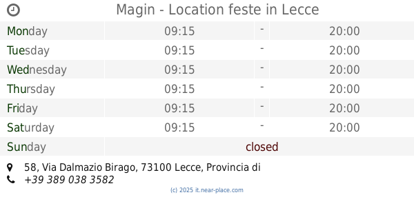
Magin - Location feste
Via Dalmazio Birago, 58, Lecce
Park
read more
40.576 km
Percorso benessere
Zona Monte
Park
read more
40.981 km
Parco
Lecce
Park
read more
41.145 km
Piazza Partigiani
Lecce
Park
read more
42.255 km
Parco Tafuro
Lecce
Park
read more
42.681 km
Parco Beatrice D'Aragona
Castromediano
Park
read more
46.25 km
Villa Carla
Lequile
Park
read more
52.345 km
Pozzo Le Chiuse Arif
Caprarica di Lecce
Park
read more
📑
all categories
Accounting
Administrative area level 1
Administrative area level 2
Airport
Amusement park
Aquarium
Art gallery
Atm
Bakery
Bank
Bar
Beauty salon
Bicycle store
Book store
Bowling alley
Bus station
Cafe
Campground
Car dealer
Car rental
Car repair
Car wash
Casino
Cemetery
Church
City hall
Clothing store
Colloquial area
Convenience store
Country
Courthouse
Dentist
Department store
Doctor
Electrician
Electronics store
Embassy
Finance
Fire station
Florist
Food
Funeral home
Furniture store
Gas station
General contractor
Grocery or supermarket
Gym
Hair care
Hardware store
Health
Hindu Temple
Home goods store
Hospital
Insurance agency
Jewelry store
Laundry
Lawyer
Library
Light rail station
Liquor store
Local government office
Locality
Locksmith
Lodging
Meal delivery
Meal takeaway
Mosque
Movie rental
Movie theater
Moving company
Museum
Natural feature
Neighborhood
Night club
Painter
Park
Parking
Pet store
Pharmacy
Physiotherapist
Place of worship
Plumber
Point of interest
Police
Political
Post office
Premise
Real estate agency
Restaurant
Roofing contractor
Route
Rv park, camping
School
Shoe store
Shopping mall
Spa
Stadium
Storage
Store
Subpremise
Subway station
Supermarket
Synagogue
Taxi stand
Train station
Transit station
Travel agency
University
Veterinary care
Zoo
administrative area level 3
sublocality level 1
↑