Gas station nearby IP
Italy
Gas station nearby IP
IP
Via Napoli, 357, Bari Italien
contacts phone
:
+39
Latitude:
41.1299227
, Longitude:
16.8328479
read more
nearest Gas station
135 m
Zaza
Via Napoli, 357, Bari
Gas station
read more
139 m
Eni
Via Napoli 338, Bari
Gas station
read more
140 m
Agip
Via Napoli, 338, Bari
Gas station
read more
156 m
Franco Vittorio E Francesco Snc
Via Napoli, 338, Bari
Gas station
read more
174 m
Tamoil
Via Napoli, Bari
Gas station
read more
587 m
Ip
Viale Saverio Mercadante, Bari
Gas station
read more
588 m
Stazione Di Servizio Di De Lucia Domenico (Api)
Viale Saverio Mercadante, Bari
Gas station
read more
712 m
Esso
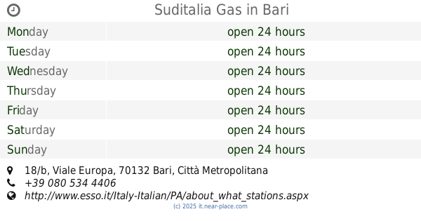
Viale Europa, 18/B, Bari
Gas station
read more
716 m
Q8
Viale Europa, Bari
Gas station
read more
724 m
Stazione Metano
Viale Europa, 18, Bari
Gas station
read more
735 m
Esso SuditaliaGas srl
Italy
Gas station
read more
742 m
Suditalia Gas
Viale Europa, 18/b, Bari
Gas station
read more
749 m
Stazione Di Servizio (Q8)
Via Napoli, 364, Bari
Gas station
read more
810 m
Q8
Via Napoli, Bari
Gas station
read more
849 m
Q8Easy - Servizi & Gestioni Italia S.R.L.
Via Napoli, Bari
Gas station
read more
1.58 km
Amoruso Giacomo
Via Brigata Regina, 129, Bari
Gas station
read more
1.651 km
Stazione Di Servizio Di Perrino Elio (Q8)
Via Francesco Crispi, 247, Bari
Gas station
read more
1.662 km
Total Erg
Via Brigata Regina, 53, Bari
Gas station
read more
1.731 km
Minniti Bruno
Via Bruno Buozzi, 54, Bari
Gas station
read more
1.804 km
Eni
Via Bruno Buozzi 54/56, Bari
Gas station
read more
1.854 km
Desomit Ufficio Comm.le
Strada Vicinale Glomerelli, 4-10, Bari
Gas station
read more
1.865 km
Desomit S.R.L.
3 Strada Vicinale Glomerelli, Bari, BA 70132
Gas station
read more
1.875 km
Total Erg
Viale Europa, Bari
Gas station
read more
2.126 km
A Posto
Via Giovanni Bovio, Bari
Gas station
read more
2.283 km
Indipendente Bari
Lungomare IX Maggio, Bari
Gas station
read more
📑
all categories
Accounting
Administrative area level 1
Administrative area level 2
Airport
Amusement park
Aquarium
Art gallery
Atm
Bakery
Bank
Bar
Beauty salon
Bicycle store
Book store
Bowling alley
Bus station
Cafe
Campground
Car dealer
Car rental
Car repair
Car wash
Casino
Cemetery
Church
City hall
Clothing store
Colloquial area
Convenience store
Country
Courthouse
Dentist
Department store
Doctor
Electrician
Electronics store
Embassy
Finance
Fire station
Florist
Food
Funeral home
Furniture store
Gas station
General contractor
Grocery or supermarket
Gym
Hair care
Hardware store
Health
Hindu Temple
Home goods store
Hospital
Insurance agency
Jewelry store
Laundry
Lawyer
Library
Light rail station
Liquor store
Local government office
Locality
Locksmith
Lodging
Meal delivery
Meal takeaway
Mosque
Movie rental
Movie theater
Moving company
Museum
Natural feature
Neighborhood
Night club
Painter
Park
Parking
Pet store
Pharmacy
Physiotherapist
Place of worship
Plumber
Point of interest
Police
Political
Post office
Premise
Real estate agency
Restaurant
Roofing contractor
Route
Rv park, camping
School
Shoe store
Shopping mall
Spa
Stadium
Storage
Store
Subpremise
Subway station
Supermarket
Synagogue
Taxi stand
Train station
Transit station
Travel agency
University
Veterinary care
Zoo
administrative area level 3
sublocality level 1
↑