Park nearby Area Tavoli
Italy
Park nearby Area Tavoli
Area Tavoli
Quartiere IX Appio Latino, Roma Italy
contacts phone
:
+39
Latitude:
41.8626763
, Longitude:
12.5198577
read more
nearest Park
72 m
Giardino Botanico
Rome
Park
read more
364 m
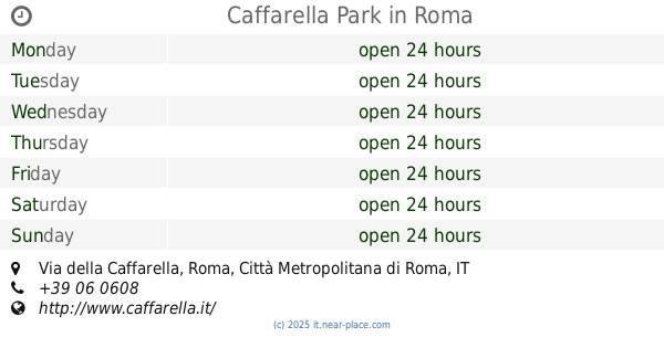
Caffarella Park
Via della Caffarella, Roma
Park
read more
589 m
Area Tavoli
Via Latina, 405, Roma
Park
read more
595 m
Entrata caffarella bbq a dx
Via Gennaro Mondaini, 58, Roma
Park
read more
696 m
Parco dellaCaffarella. Ingresso largo Pitro Tacchi venturi
Largo Pietro Tacchi Venturi, Roma
Park
read more
774 m
Bosco Sacro
Quartiere IX Appio Latino, Roma
Park
read more
945 m
Giardino Beato Giovanni Maria Fusco
Via Giovanni Botero, 55, Roma
Park
read more
1.052 km
Villa Lazzaroni
Via Appia Nuova, 522, Roma
Park
read more
1.242 km
Fontana Parco della Caffarella
Via Centuripe, Roma
Park
read more
1.324 km
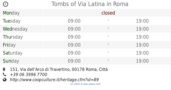
Tombs of Via Latina
Via dell'Arco di Travertino, 151, Roma
Park
read more
1.402 km
Area Cani Parco Scott
Quartiere XX Ardeatino, Roma
Park
read more
1.418 km
Giardino Delle Rose
Italy
Park
read more
1.429 km
Parco Scott
Roma
Park
read more
1.492 km
Ingresso Parco della Caffarella
Via Segesta, Roma
Park
read more
1.574 km
Parco Regionale Appia Antica
Via Appia Antica, 42, Roma
Park
read more
1.661 km
Area Gioco Bambini
Via Segato Girolamo, 23, Roma
Park
read more
1.73 km
Giardino Pantalica
Rzym
Park
read more
1.73 km
Giardino Pantalica
Rom
Park
read more
1.757 km
Tenuta di Tormarancia
Quartiere XX Ardeatino, Roma
Park
read more
1.968 km
Parco della Torre
Viale Tor Marancia, 29, Roma
Park
read more
2.114 km
Area Cani Via Nocera Umbra
Quartiere VIII Tuscolano, Roma
Park
read more
2.118 km
Parco Degli Scipioni
Viale delle Mura Latine, 24, Roma
Park
read more
2.446 km
Parco San Sebastiano
Rome
Park
read more
2.446 km
Parco San Sebastiano
Rom
Park
read more
2.446 km
Parco San Sebastiano
Rzym
Park
read more
📑
all categories
Accounting
Administrative area level 1
Administrative area level 2
Airport
Amusement park
Aquarium
Art gallery
Atm
Bakery
Bank
Bar
Beauty salon
Bicycle store
Book store
Bowling alley
Bus station
Cafe
Campground
Car dealer
Car rental
Car repair
Car wash
Casino
Cemetery
Church
City hall
Clothing store
Colloquial area
Convenience store
Country
Courthouse
Dentist
Department store
Doctor
Electrician
Electronics store
Embassy
Finance
Fire station
Florist
Food
Funeral home
Furniture store
Gas station
General contractor
Grocery or supermarket
Gym
Hair care
Hardware store
Health
Hindu Temple
Home goods store
Hospital
Insurance agency
Jewelry store
Laundry
Lawyer
Library
Light rail station
Liquor store
Local government office
Locality
Locksmith
Lodging
Meal delivery
Meal takeaway
Mosque
Movie rental
Movie theater
Moving company
Museum
Natural feature
Neighborhood
Night club
Painter
Park
Parking
Pet store
Pharmacy
Physiotherapist
Place of worship
Plumber
Point of interest
Police
Political
Post office
Premise
Real estate agency
Restaurant
Roofing contractor
Route
Rv park, camping
School
Shoe store
Shopping mall
Spa
Stadium
Storage
Store
Subpremise
Subway station
Supermarket
Synagogue
Taxi stand
Train station
Transit station
Travel agency
University
Veterinary care
Zoo
administrative area level 3
sublocality level 1
↑