Train station nearby Milano San Cristoforo
Italy
Train station nearby Milano San Cristoforo
Milano San Cristoforo
Italy Italien
contacts phone
:
+39
Latitude:
45.4425626
, Longitude:
9.1300886
read more
nearest Train station
1.796 km
Corsico
via, Via Niccolò Copernico, 19, Corsico
Train station
read more
2.912 km
Milano Romolo
Italy
Train station
read more
3.305 km
Milano Porta Genova
Piazzale Stazione Genova, 4, Milano
Train station
read more
3.31 km
Stazione FS Cesano Boscone
Italy
Train station
read more
4.563 km
Stazione Ferroviaria Cadorna
Piazzale Luigi Cadorna, Milano
Train station
read more
4.563 km
Milano Cadorna
Piazzale Luigi Cadorna, Milano
Train station
read more
4.945 km
Milano Domodossola
Italy
Train station
read more
5.525 km
Trezzano sul Naviglio railway station
Italy
Train station
read more
6.458 km
Milano Porta Garibaldi Sotterranea
Piazza Sigmund Freud, Milano
Train station
read more
6.458 km
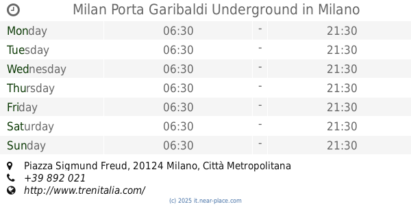
Milan Porta Garibaldi Underground
Piazza Sigmund Freud, Milano
Train station
read more
6.458 km
Milano Porta Garibaldi
Piazza Sigmund Freud, Milano
Train station
read more
6.487 km
Milano Porta Romana
Italy
Train station
read more
6.875 km
Milano Lancetti
Italy
Train station
read more
7.16 km
Milano Certosa Railway Station
Italy
Train station
read more
7.399 km
Milano Centrale
Italy
Train station
read more
7.528 km
Bahnhof Milano Centrale
Piazza Duca d'Aosta, 1, Milano
Train station
read more
10.039 km
S.Donato Milanese
Italy
Train station
read more
10.064 km
Novate Milanese
Italy
Train station
read more
11.158 km
Bollate Centro
Italy
Train station
read more
11.641 km
Locate Triulzi
Italy
Train station
read more
13.454 km
S.Giuliano Milanese
Italy
Train station
read more
13.809 km
Segrate
Italy
Train station
read more
13.871 km
Vanzago-Pogliano
Italy
Train station
read more
14.611 km
Garbagnate Parco Groane
Italy
Train station
read more
15.214 km
Vittuone Arluno
Italy
Train station
read more
📑
all categories
Accounting
Administrative area level 1
Administrative area level 2
Airport
Amusement park
Aquarium
Art gallery
Atm
Bakery
Bank
Bar
Beauty salon
Bicycle store
Book store
Bowling alley
Bus station
Cafe
Campground
Car dealer
Car rental
Car repair
Car wash
Casino
Cemetery
Church
City hall
Clothing store
Colloquial area
Convenience store
Country
Courthouse
Dentist
Department store
Doctor
Electrician
Electronics store
Embassy
Finance
Fire station
Florist
Food
Funeral home
Furniture store
Gas station
General contractor
Grocery or supermarket
Gym
Hair care
Hardware store
Health
Hindu Temple
Home goods store
Hospital
Insurance agency
Jewelry store
Laundry
Lawyer
Library
Light rail station
Liquor store
Local government office
Locality
Locksmith
Lodging
Meal delivery
Meal takeaway
Mosque
Movie rental
Movie theater
Moving company
Museum
Natural feature
Neighborhood
Night club
Painter
Park
Parking
Pet store
Pharmacy
Physiotherapist
Place of worship
Plumber
Point of interest
Police
Political
Post office
Premise
Real estate agency
Restaurant
Roofing contractor
Route
Rv park, camping
School
Shoe store
Shopping mall
Spa
Stadium
Storage
Store
Subpremise
Subway station
Supermarket
Synagogue
Taxi stand
Train station
Transit station
Travel agency
University
Veterinary care
Zoo
administrative area level 3
sublocality level 1
↑