Bar nearby Bar Siar
Italy
Bar nearby Bar Siar
Bar Siar
Via Enrico Stevenson, 7, Roma Italia
contacts phone
:
+39
Latitude:
41.92001
, Longitude:
12.5203769
read more
nearest Bar
216 m
Suan Bar
Piazza Armellini Mariano, 9, Roma
Bar
read more
250 m
Juice Bar
Largo XXI Aprile, 7, Roma
Bar
read more
398 m
Bar Tavola calda "Thomas"
Via Oreste Tommasini, 57, Roma
Bar
read more
414 m
Ge.Bar Di Rossetti Luciano E C. Snc
Via Oreste Tommasini, 38, Roma
Bar
read more
444 m
Enoteca Bar Carrera
Via Giuseppe Gatteschi, 15, Roma
Bar
read more
469 m
Toomuch
Piazza Oreste Tommasini, Roma
Bar
read more
500 m
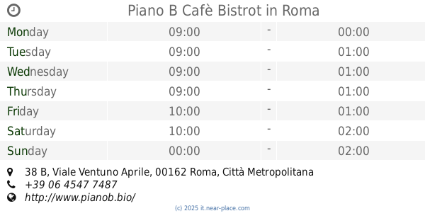
Piano B Cafè Bistrot
Viale Ventuno Aprile, 38 B, Roma
Bar
read more
502 m
Marino Alessandro
Via Spalato, 2, Roma
Bar
read more
577 m
enoteca boni e non solo di giulia pierozzi
Via Giacomo Boni, 32, Roma
Bar
read more
610 m
Malto Misto - Craft Beer Bar
Via di S. Orsola, 35/37, Roma
Bar
read more
615 m
Bar Garden Di Terra Annamaria
Via Livorno, 13, Roma
Bar
read more
723 m
OwLodge
Via Michele di Lando, 56, Roma
Bar
read more
809 m
Ceresa Immobiliare S.R.L.
Corso Trieste, 132, Roma
Bar
read more
809 m
Bar Er Buco
Via Michele di Lando, 88, Roma
Bar
read more
816 m
Bar Paradise
Viale Gorizia, 37, Roma
Bar
read more
848 m
Umbertoel Sedawi Magdi Makhtar
Via Panaro, 22/24, Roma
Bar
read more
855 m
La Cannoleria Siciliana - Corso Trieste
Corso Trieste, 100, Roma
Bar
read more
857 m
Bar Garofalo
Via della Batteria Nomentana, 40/a, Roma
Bar
read more
858 m
Cafe' Art.
Via Catanzaro, 40-42, Roma
Bar
read more
922 m
Coffee Hour
Via Massaciuccoli, 67, Roma
Bar
read more
963 m
Bar Gelateria
Corso Trieste, 72, Roma
Bar
read more
1.031 km
Sgamma Pietro
Via Eleonora d'Arborea, 15, Roma
Bar
read more
1.12 km
DOHA
Circonvallazione Nomentana, 500/502, Roma
Bar
read more
1.19 km
Tree Generation Srl
Nuova Circonvallazione Interna, 540, Roma
Bar
read more
1.295 km
La Casa del Cremolato
Via di Priscilla, 18, Roma
Bar
read more
📑
all categories
Accounting
Administrative area level 1
Administrative area level 2
Airport
Amusement park
Aquarium
Art gallery
Atm
Bakery
Bank
Bar
Beauty salon
Bicycle store
Book store
Bowling alley
Bus station
Cafe
Campground
Car dealer
Car rental
Car repair
Car wash
Casino
Cemetery
Church
City hall
Clothing store
Colloquial area
Convenience store
Country
Courthouse
Dentist
Department store
Doctor
Electrician
Electronics store
Embassy
Finance
Fire station
Florist
Food
Funeral home
Furniture store
Gas station
General contractor
Grocery or supermarket
Gym
Hair care
Hardware store
Health
Hindu Temple
Home goods store
Hospital
Insurance agency
Jewelry store
Laundry
Lawyer
Library
Light rail station
Liquor store
Local government office
Locality
Locksmith
Lodging
Meal delivery
Meal takeaway
Mosque
Movie rental
Movie theater
Moving company
Museum
Natural feature
Neighborhood
Night club
Painter
Park
Parking
Pet store
Pharmacy
Physiotherapist
Place of worship
Plumber
Point of interest
Police
Political
Post office
Premise
Real estate agency
Restaurant
Roofing contractor
Route
Rv park, camping
School
Shoe store
Shopping mall
Spa
Stadium
Storage
Store
Subpremise
Subway station
Supermarket
Synagogue
Taxi stand
Train station
Transit station
Travel agency
University
Veterinary care
Zoo
administrative area level 3
sublocality level 1
↑